Introducing Your Wild Patch

Yusef Samari, WWBIC GIS Officer and Project Lead yusef@westwalesbiodiversity.org.uk What wildlife is living in your local patch – be that your garden, favourite nature reserve, local park, or whatever ‘your patch’ means to you? How is your patch contributing to the wider biodiversity of your area? What contribution could it potentially make?
These are the kind of questions we would like to get people thinking about in the ‘Your Wild Patch’ project, which aims to both build natural history and recording skills in the community, and to help people to use those skills to record the wildlife on their local patch – or further afield!
This project, running until March 2027, is funded by Welsh Government’s Local Places for Nature biodiversity grant scheme, via the Ceredigion, Carmarthenshire and Pembrokeshire Local Nature Partnerships, who we are working closely with on the project.
![]()
Current project logo – artwork by Carys May
Over the next two years, we will be developing a system for people to adopt a patch to record, alongside resources to help them start to identify their local wildlife and put their findings into context. We will also be running a program of sessions called ‘West Wales Wild Watch’ - regular, open recording sessions, at locations around the region, where people can develop their skills in an informal group setting. Get in touch to be added to the mailing list if you want more details on these!
We are still in the early stages of the project, and are working with various groups, from beginners to seasoned recorders, to help us trial and develop resources. If you are interested in taking part, or hosting some recording sessions on your patch, please get in touch! This article outlines what we’ve been up to so far, what we have learned and where we are heading.
Work so far – resources
Recording Summaries
These ‘recording summaries’ can be produced for any OS 1km square, or for any site boundary. The example below is for my ‘home square’ – including the southern portion of Cardigan and surrounding countryside.
This summary gives an overall summary of the total records from the square, maps them and breaks down the number of different species recorded per taxon group. It also breaks down the number of records per year, to give an idea of periods of recording intensity. These are meant to complement the existing ‘What’s in My Area’ function on Aderyn, where users can search for a non-sensitive species list for any 1km square - aderyn.lercwales.org.uk/public/search
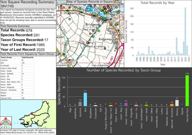
A recording summary for the Ordnance Survey 1km square SN1745
Many people are amazed to see just how many species have been recorded from their square, particularly if they are unfamiliar with certain groups and were not expecting to see hundreds of species of moth, or dozens of species of mollusc! Equally, many are amazed to see how few species have been recorded from certain groups.
So far, we have produced over 100 of these square summaries, and have yet to find one that doesn’t appear to have obvious gaps in at least one species group, even for squares with very large numbers of total records. These summaries are a work in progress and there are many ways they can be improved.
Nonetheless, even in their current form though, they have been very effective in highlighting gaps, generating conversation and in many cases, motivating people to get out and try and fill those gaps.
For example, I can see there are only 2 species of fungi recorded from my square, and no bryophytes, which gives me some interesting winter focuses as I look to improve on both of those groups.
‘Starter Species Lists’
These documents are produced to go alongside and complement the recording summaries. They provide a list of 100 readily identifiable species, covering all the major species groups outlined in the recording summary, and also note when they were last recorded in the patch, if at all – at least according to records held by WWBIC. Familiar species have deliberately been included.
For some of the often lesser-known groups, such as lichens, mosses, fungi and most invertebrates, a selection of species have been chosen that are relatively easy to identify for the beginner, have obvious features that can be confirmed without microscopy, and are very likely to be present in most patches. The screenshot below shows just the upper portion of the list for my home square.
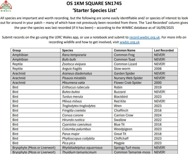
Excerpt from a ‘Starter Species List’ for SN1745
The list is not proscriptive of what to record, but it is hoped that it can provide some good starting points, for those that would find that helpful, especially beginners, for who recording can potentially seem like an endless and daunting task. The full list of 100 species prints onto one double-sided sheet of A4, so we have been able to take one along to each session we have run, specific for that location.
Most of the time, when these are shown to a group, at least one person exclaims “ooh, I’ve seen that here before!”. Even though the list is full of common species, we have yet to come across a square for which this list is ‘complete’, or even one which has at least one ‘tick’ for every species group!
Work so far – events
As of 19th November 2025, we have run 29 recording events across the region, including 10 each in Ceredigion and Pembrokeshire and 9 in Carmarthenshire, with a total of 176 attendees so far and 200+ people on the mailing list. This will probably be out of date by the time you read this, so check here for the latest info – wwbic.org.uk/projects/your-wild-patch-eich-darn-gwyllt/
Most of these have been advertised as part of our ‘West Wales Wild Watch’ series. These are free, open, informal sessions that provide a space for identification and recording training, and an opportunity to practise skills in a friendly group setting. Each session usually runs from 10am – 1pm. We cover the basics of recording, introduce the LERC Wales app, then explore the local habitats, identifying and recording what we find along the way, focusing on different groups in different seasons.
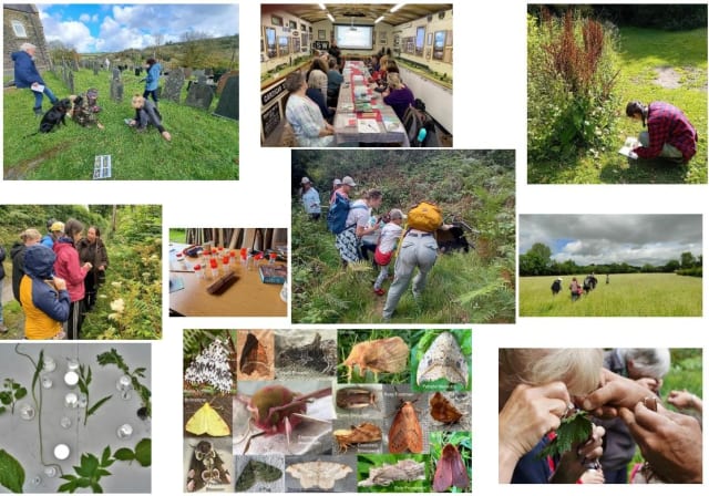
Photos from WWBIC recording/ training events – from both Your Wild Patch and Recording Toolkit projects.
As well as these open, outdoor sessions, we continue to run more focused training with specific community groups, often featuring an indoor classroom session. Groups we have worked with so far include Carmarthenshire Meadows Group, Parc Cerrig Community Garden from Goodwick, Borth Community Hub, Pobwl y Fforest at Keepers, Brechfa and several others.
Feedback from the sessions have been very positive, with responses indicating the sessions have helped people to build confidence in recording and identification, and to notice more in nature. We are starting to see a small but steadily growing cohort of regular attendees and regular recorders emerge.
Where we’re going
The map below shows event locations for the project and all the 1km squares for which we have sent out information packs to people, as of 18/11/2025. In addition to this, something like 45 people have been sent resources for specific site boundaries, which are also spread across the region, and range from private gardens covering a few square metres, to community woodlands covering hundreds of hectares.
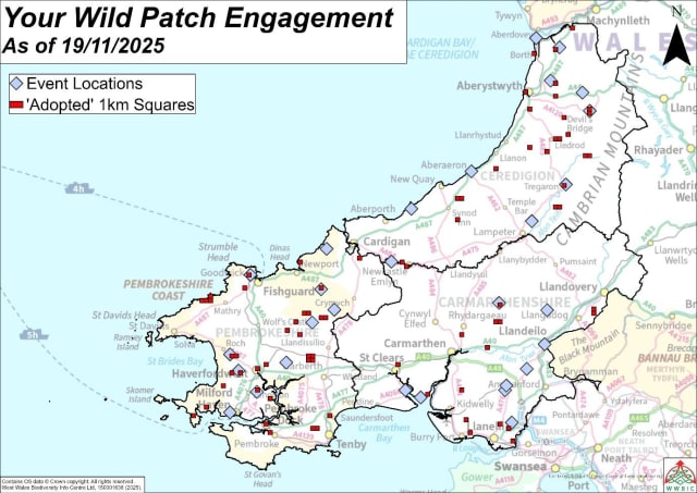
Locations of events and squares that have been sent resources for the project so far
Even at this early stage of the project, this represents a significant reach. We plan to keep on building and growing this community, but we also want to help them to build their skills, and put those skills to use. The next step is refining what ‘adopting’ a patch might formally look like.
We are taking an open, co-design approach to this process, starting out with conversations with our local partners in conservation who use WWBIC data, local species experts, budding and seasoned recorders, and the various groups we are working with. This is a slower approach than us just knocking something together, but hopefully increases the chances of creating something meaningful and robust.
We aim to work towards a flexible ‘recording plan’ that can be followed over a year for a patch, that works through the different species groups, seasons, habitats, and links into local nature recovery objectives.
There will be plenty to do over the next 18 months, which is why we are currently recruiting for a full-time Project Officer to support WWBIC staff on the project. Keep your eyes peeled for that advert soon, and watch this space for future updates! If you would like to join any West Wales Wild Watch events, or receive any information on your own patch, get in touch!